

Collecting Data From Alpine Peaks to Valley Streams
Why High Elevation Environments Matter for Sustainable Water Management
Project supported by the ACC Environment Grant
Talus Lakes, B.C. Photo: Living Lakes Canada
Talus Lakes, B.C. Photo: Living Lakes Canada
If you’ve ever hiked in the mountains, you’ve likely felt the wildness of these spaces. At first glance, it may seem desolate — isolated from communities far below. But if you pause and look around, signs of life begin to emerge. These rugged high elevation environments are full of biodiversity and deeply connected to the health of downstream communities and ecosystems.
Last summer, the Living Lakes Canada high elevation monitoring field team experienced this firsthand. They stumbled across foraging moose, lumbering black bears, alpine birds singing in chorus, and aquatic life thriving in lakes tucked between towering peaks. As staff inflated their kayaks and paddled across these remote lakes to collect vital water data, it was evident to them just how important these alpine systems are for supplying clean, cold freshwater.
Monitoring freshwater, from alpine heights to valley bottoms, is more important than ever as climate change intensifies water management challenges. By collecting and sharing critical water and climate data through the Columbia Basin Water Monitoring Framework (CBWMF) network, Living Lakes Canada is helping to build the foundation for informed, science-based decision making around sustainable freshwater management in the B.C. Columbia Basin, one of the essential water towers in the Pacific Northwest.
Snowpack Data
Throughout the winter, Living Lakes hydrologist Paul Saso sticks skins onto his skis and climbs to two high elevation snowpack and climate monitoring sites located near the north end of Kootenay Lake. Both sites sit at roughly 2,000 metres elevation. The Lost Ledge site is located in the Selkirk Mountains on the west side of the lake and the Purcell site is on the east side of the lake.
At each site, the snow survey includes measuring snow depth, density, and snow water equivalent to understand how much water is stored in the snowpack. The data is submitted to the provincial database and contributes to British Columbia’s monthly Snow Survey and Water Supply Bulletins.
Living Lakes also partners with Talus Lodge, Valhalla Mountain Touring Lodge and Alpine Club of Canada’s Kokanee Glacier Cabin, who share their climate and snow data through the Columbia Basin Water Hub.
Together, these snow monitoring efforts help track the impacts of climate change on snowpack and enable streamflow predictions, allowing for better preparation and adaptation to water challenges.
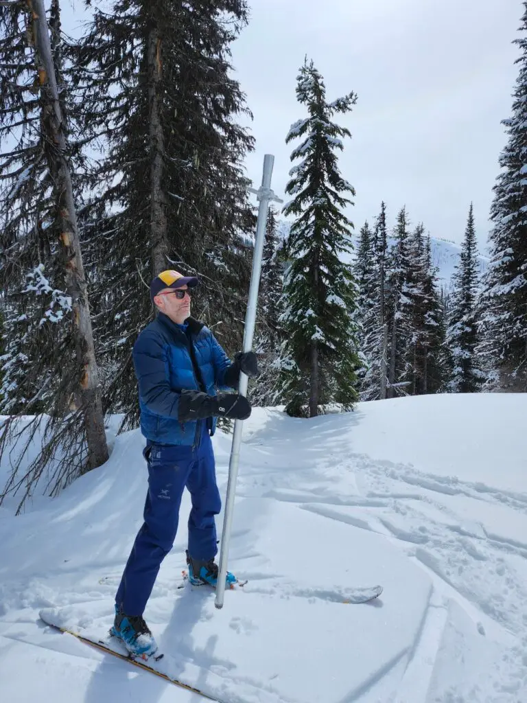
Paul Saso en route to the Purcell snow survey site. Photo: Living Lakes Canada
Paul Saso en route to the Purcell snow survey site. Photo: Living Lakes Canada
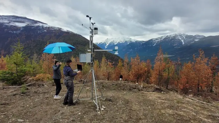
Climate Stations
Seven Living Lakes climate stations collect essential year-round data such as temperature, precipitation, wind speed and direction. In the upcoming field season, the CBWMF network will expand its reach with a new climate station in the West Kootenays.
These stations quietly capture the pulse of high elevation environments by recording every storm, heat wave, and dry spell. When combined with snowpack data, they provide valuable insights into how much water is stored within a watershed system and how water supply and flood risk vary from season to season.
Lake Monitoring
High elevation lakes are on the frontlines of climate change impacts. Earlier snowmelt and lake ice-off, increased glacial melt, and warmer temperatures are changing lakes in mountain environments. And because these lakes feed downstream watersheds, what happens here doesn’t stay in the high mountains—it trickles down.
That’s why, over the past three field seasons, Living Lakes monitored eight high elevation lakes across the Kootenays, from the Talus Lakes in the East to the rugged Kokanee and Valhalla Provincial Parks in the West. The baseline data collected ranges from water temperature and clarity to pH, dissolved oxygen, and the presence of algae and aquatic life. This data provides a valuable snapshot of lake conditions and helps lay the foundation for future research and monitoring.
Citizen Science
In collaboration with the Alpine Club of Canada, Living Lakes runs an iNaturalist project to support community-based biodiversity tracking in the alpine. Citizen scientists have contributed nearly 300 observations across the Purcell and Selkirk Mountains, identifying close to 200 alpine flora and fauna species.
Among the findings are species at risk, like the Western Toad, listed as a species of conservation concern on BC’s Yellow List. Over half of the submitted observations have reached Research Grade status, meaning they’ve been verified by the iNaturalist community and can be used by researchers to better understand climate impacts on alpine biodiversity.
This growing collection offers a valuable, publicly accessible inventory of alpine species that can contribute to scientific research and global biodiversity databases.
Value of Open Data
Collecting and sharing freshwater data is essential for data-driven decision making and supports an adaptive, transparent approach to watershed management. That’s why all snowpack, climate, and water monitoring data is publicly available on the Columbia Basin Water Hub—an award-winning open-access platform hosted by Living Lakes.
This centralized database offers easy access to regional data, making it easier to compare findings across multiple sources and foster collaboration in science-based water stewardship.
By monitoring headwater environments, engaging citizen scientists, and making data openly accessible, we can deepen our understanding of these vital systems and better protect the waters that flow from alpine peaks to valley streams, and beyond.
Living Lakes Canada was the recipient of the 2024 Alpine Club of Canada Environment Grant.
The ACC Environment Grant
The ACC Environment Grant is issued annually from a permanent fund to be used to create a legacy of environmental improvement.
The purpose of the Fund is to provide support that contributes to the protection and preservation of mountain and climbing environments, including addressing climate change in mountain ecosystems, the preservation of alpine flora and fauna in their natural habitat and support for mountain cultures that rely on these ecosystems.