
ACC + MLP Repeat Photography Challenge
ACC + MLP Repeat Photography Challenge
Details and historical photos provided by Mary Sanseverino on behalf of the Mountain Legacy Project.
For more information on this project, please visit the Mountain Legacy Project website.
Welcome to the Alpine Club of Canada + Mountain Legacy Project (MLP) Repeat Photography Challenge. MLP and ACC have curated a few historic mountain photos from the turn of the 20th century. They were all taken in the summer months and feature glaciers, snow, and ice.
As some of you may know, the Mountain Legacy Project from the School of Environmental Studies at the University of Victoria focuses (pun intended) on repeating historic mountain images from the Canadian mountain west. The images featured in our Challenge are from the MLP collection and are courtesy of Library and Archives Canada / Bibliothèque et Archives Canada. None of them have been repeated.
Your challenge – pick a historical image, get out and repeat it, send the repeat in to the ACC. MLP researchers will examine the shots and those that are accurate enough will – with the photographer’s permission of course – be added into the MLP collection.
The ACC will also feature the best repeats on the Glacier Year Hub and at the Summit Shaker in October and those photographers will win a prize pack and tickets to the party.
Repeat photography locations
There are nine photos in the Challenge – some are very easy to get to, while others are more difficult. They all feature outstanding views of our mountains and the glaciers and icefields that are integral to these landscapes. They all lend themselves to helping us tell stories of change in the Canadian mountain west.
- More challenging photo locations
- Easier to access photo locations
Bow Glacier below Iceberg Lake
Photo taken in 1903 by A.O. Wheeler. This one might be a challenge as the glacier is gone from this location. But use the cliffs at the right side and the mountain behind to line up the repeat.
Fay Glacier from below Sentinel Pass, Banff National Park
Exact location is not known. Views of the Fay Glacier, (L-R)Mt Babel, Wazi (Mt Fay), and Nûm (Mt Little) with Yamnî (Bowlen) behind. The names Wazi, Nûm, and Yamnî are the original Stoney Nakota names for these peaks. Photo taken in 1903 by A.O. Wheeler. We are not sure where exactly this is taken from, but it looks like a view heading up to Sentinel Pass. The actual location is probably someplace off the trail to the east (the right of the trail as you are walking up). It would be wonderful to find this location and repeat the shot!
Sunwapta Peak, Jasper National Park
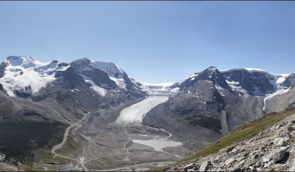
This one might not be possible for 2025 – the area is currently closed due to the impacts of the 2024 Jasper Wildfire. But if it does reopen it would be well worth attempting the repeats. There are several historic photos from here but the one selected for this Challenge looks southward to iconic Mt Athabasca. Photo taken in 1919 by A.O. Wheeler and Alan Campbell as part of the Interprovincial Boundary Survey between Alberta and BC.
Cirque Peak, Banff National Park
There are several photos here to repeat, but this one, looking SE into the area behind Dolomite Peak (Mt Hector in the background) will be a good one to focus on. Lots of change to note here. Photo taken in 1903 by A.O. Wheeler.
Mt Gordon, Yoho National Park
There are a number of photos to repeat from here, but this one is probably the easiest to line up and repeat. That's Mont des Poilus with Arete Peak behind. Photo taken in 1903 by A.O. Wheeler.
Mt Abbott at the Old Observatory, Glacier National Park
Photo taken in 1901 by A.O. Wheeler. Views of Mt Sir Donald from the Mt Abbott Trail. There are other photos here too that look northward to Mt Rogers, Hermit Mtn, and the Hermit Glacier.
Mt Fairview above Lake Louise
On Mt Fairview looking down into the Plain of the Six Glaciers, Banff National Park. Photo taken in 1903 by A.O. Wheeler. There are lots more photos from this location:
Mt Thompson, Banff National Park
There are a number of photos up here - any/all would be great to repeat, but this one looks down on Peyto Glacier. It might be difficult to find the best repeat location as the top of Thompson is wide and the Peyto Glacier might not be visible. Use the alignment between Caldron (right of centre), Patterson (centre) and Mistaya (on the far left) to help line up the shot.
Mt Jimmy Simpson, Banff National Park
This is a challenging location to get to - but if anyone does get up there, it would be great to get this image particularly - but all the rest at this location would be wonderful to have too. This photo, taken in 1903 by A.O. Wheeler, looks down at the mighty Peyto Glacier.
What to do the in field
You can use a “real” camera if you like, or a cell phone. Both will deliver compelling photos that help tell the story of what is different and what remains the same on these rugged landscapes.
Each historic image comes in two “flavours” – one is a copy of the image without any additions to it. The other is a copy of the same image but with the black frame cropped out and a crosshair grid added over top. Both are useful to get a sense of what is in each image, but the crosshair gridded photo will be most useful in the field.
The images themselves are pretty easy to repeat – try to get your camera looking at about the same centre spot as the historic photo (where the crosshairs meet). To help with this it can be handy to print off a copy of the crosshair grid image and use it for comparison when taking the photo.
If you and your party travel with cell phones it is equally as effective to put a copy of the crosshair grid photo on two or more phones. Then, when taking the repeat, you can use one of the phones as the reference photo. This frees up the other phone to do the repeat (if you are using a cell phone for capturing repeat photos).
Once you’ve got the centre spot approximately located, try to keep your camera level – no tilting if you can help it. Use the centre horizon line on the crosshair grid photo as a reference.
By all means, try your best to get a repeat that is nicely lined up with the historic, but don’t let perfection stand in your way! The key thing is to get out on the land, make photos and let the images help us tell our mountain stories.
Thanks, and have fun!